Monday 24 October 2011

October 2011 - Congo - Niyrangogo Crater


We were left with a couple of days of doing nothing in the small border town of Uganda while waiting for Fred’s Rwandan visa. And as always, when one plan does not work as expected something else comes up. This is how we ended up seeing an active volcano with burning lava and spend a night in the Democratic Republic du Congo! Real adventure, just to keep us entertained for some time longer.
The Nyiragongo volcano is one if the few active ones remaining and one of the even fewer that contain a lave lake. The volcano erupted for the last time in 2002; the city below had time to evacuate leading to ‘only’ 50 fatalities and one quarter of the city being fully destroyed; the previous eruption some 20 years back led to more than 300 deaths. Nowadays the volcano is being monitored by researchers and even has basic tourist facilities.
Whether the Congolese researchers are able to accurately predict an eruption is questionable especially when the over-developed Japanese were not in a position to foresee their earthquake and associated tidal wave, but we decided that this was worth taking the risk.
Almost nobody knows or speaks about it and it is not advertised as one of the major attractions of Eastern Africa, like in the end most of the things that can get the money flowing from the Whiteys. That is because the volcano is in the Congo. In the Easter part of the Democratic Republic du Congo, just above the city of Goma. Therefore, another fairly obvious factor to take into account apart from a potential eruption was the general situation on this side of the country.
The history of this area is known and not much needs to be said. The situation however, has been stable for some time now and the volcano can be booked via the very (!) fancy internet booking page of the associated Virungas national park (an initiative by a Dutch NGO). This definitely won some points on the psychological safety scale... Apart from that we had met Manu, a Spaniard, professional backpacker and tour-organiser, who had just spend a week there interacting with the staff of the national park, assessing and organising the situation to begin bringing tourists to the area from next year. He would put us in touch with the rangers and they would take care of us as they did with him.

After a longer brainstorming session we decided that fear is momentary while regret stays forever, we were going!
We were picked up by two rangers at the Congolese border; they helped us with the officials and ensured that we would be back the next day.
They drove us the 100 km to the volcano. The area through which we drove was from the moon; one extinct volcano next to the other, reaching altitudes of 2000 to 3500 meters on the otherwise flat surroundings. Ours, the Nyiragongo could be seen from far, at first we thought it was covered in clouds until we realised that this was smoke/condensation from its burning interior. Holly shit, it is really alive! The whole preparation and thought process had made us kind of overlook this fact; seeing it now was eye-opening.
The drive was also eye-opening and sobering. Army trucks, soldiers, safety blocks, police checks, UN trucks, UN bases, UN fancy Landcruisers, European Union army force, Red Cross tents, Unicef camps and all sorts of other never-heard armed and non-armed NGOs and foreign organisations. In-between them, the Congolese people or better to say the Congolese women and children going on with their lives. Women carrying things like everywhere in Africa, working in the fields, selling and buying vegetables on the markets, kids coming or going to school, playing in front of their houses and in the fields, looking at the fast cars driving by, overlooking all the soldiers around them.
Nobody bothered with us. Being in an official car with two rangers is definitely recommended. We arrived at the volcano after 100 km of shaking along the really bad road. There we met the rest of our hiking group, six more Umzungus from across Europe, one guide and two guards and started the ascension. It took us about 6 hours to climb the 3430 meters to the crater rim. The route up follows the lava path that the last eruption left behind, not the easiest territory to walk on.
We arrived on top, it had been raining almost the whole way up, we were soaked and frozen, up there the temperature was close to zero. Exhausted and frozen we pushed the last 3 meters to the rim only to see, nothing! The mist was too thick... Our guides assured us that it should clear up... It better should!
We tried to warm ourselfes up in the very new, very cute cabins they have built just at the tip of the crater, with rum and a meal of canned sardines and peanuts. It had gotten dark and internally warmer when the guards called us to come out and have a look.
And there is was! About 500 meters below us there was a massive pot with a 1 km diameter of burning red lava. You could see the lava boiling like a pot of water, bubbles and little explosions everywhere. You could even hear it! Even by looking at and hearing it, it was hard to comprehend what we were seeing. We do not realise it but we do live, all of us, on a burning ball of melted earth. Most of us live fully unaware of this, not that it makes any sort of practical difference but it does show you that there are greater forces surrounding us than the ones we get caught up within our daily life. All the wars people are fighting below can turn even more useless with only one eruption of the ground they are living on.
We tried to take in the view as long as we could stand the cold. The pictures are not the best, we were missing the skills and the equipment but you can see maybe a tiny bit of what we saw.
The next morning we watched the sunrise from the crater rim and then walked back down in wonderful sunshine this time.
The drive back as well as the border crossing was again hassle-free. We arrived back in the town where we had left Cruisi and went for a much dreamt –of lunch to a small cafe owned by a German woman, she even had a freshly baked Rabarbar-Streusel Kuchen!!
Fred’s visa was ready and we crossed the third border in two days, this time into Rwanda.

That was it, we have seen it and we are back again. Back with an amazing experience to remember and a lot to process. The conflict in the Congo is a complex situation and even the guards who we had with us could not tell us what it is about (!?). Speaking to a Human Rights lecturer who is applying for his Doctorate over a beer here on the lake shore of a lovely town of Rwanda we tried to get a better insight. The tensions are reaching far back and have many origins, tribal, territorial, economic (Eastern Congo is one of the richest areas) and political. Whether all the foreign ‘help’ from institutions like the UN and other NGOs are effective is ambiguous. Yes, they do maintain stability in the short term allowing women and children (mainly) to go on with their lives as we have seen but in the longer term their presence does not seem to facilitate a clear solution of the conflict but rather support the certain interest groups...
With Gadafi’s death a few days ago the comment of why we Umzungus are interfering so much in African affairs has been raised to us directly and indirectly a couple of times. The beginning of the internal African dilemma in our mind these days...
We are safe and happy, hoping the same for you!

Tuesday 18 October 2011

October 2011 - Uganda Lake Bunyoni


Our final stop in Uganda was Lake Bunyoni, it is right in the south at the border to Rwanda. It is a very pretty lake surrounded by thousands of steep hills and it has many little islands on it. Everything like everywhere in this country is so green.
Every morning the lake was covered in mist that was rolling down the hills, a quite surreal setting. It was also much colder than the rest of the country and we needed to get our woollen pullovers back out of the boxes, we had not used them since back in South Africa.
We rented canoes one day and cruised around the islands. It really feels as if you are paddling through a fairy tale and if the Monster of Loch Ness would come up from underneath you would not be too surprised.
The local-style canoes and rows are made of heavy wood; making you really appreciate the invention of polyester.
After paddling some time in zigzag we got the hang of it. Despite the locals asking us why we had taken the long way round we were quite proud of us that we managed to get from one place to the other in what had seemed to us a fairly straight line.
We also got the opportunity to try the local brews. One thing that people no matter from which continent or of which skin colour have in common is that they like to booze! The first was a brew made of wheat similar to bulgur. It is served in cups of about a litre, it looks like milk mixed up with dirt and ashes and it tastes like rotten milk with dirt and ashes, even by trying hard to be polite and maintain a sort of neutral face it was difficult when forcing it down... The second one was much better and actually enjoyable, they call it banana gin and yes it is distilled out of bananas, it smells like tequila and tastes similar, we are bringing a bottle back home for you to taste.
The natural beauty of the place, as on many occasions on this trip, is in sharp contrast to the tough reality of people’s life. Each family here has on average 9 children. People are very poor and can hardly afford to have any child but this does not seem to stop them. Contraception as we read on a toilet is apparently ‘for prostitutes and white people’ (!) fortunately this belief is slowly changing as there are more and more initiatives to educate people on “family planning”. HIV is also a big problem and most of the children have been left without parents, as a result there is one orphanage next to the other. It is good to see that most of them are being build up by locals. Most of them have foreign support but the actual initiative is up to the local people which makes it seem much more sustainable. It is nice to see the sense of community people have in supporting all those children.
At least the use, as per the sign at this school, of ‘anal cleansing materials’ is more readily promoted than condoms!
Now we are at the border with Rwanda. Luisa due to her German passport does not need a visa to enter the country but Fred does and this is not available at the border. We sort of feared this but kind of ignored it (we have not figured that one out)... Thankfully we are able to order it online and do not have to head back to Kampala but this can take up to 3 days... So we are at this small border town, below the famous Parc des Volcans where the ‘Gorillas in the Mist’ was shot, not the worst setting to be stranded for a couple of days.

October 2011 - Uganda Fort Portal Lake Region


For the drive from the North of the country to the central and southern part of Uganda we decided to take the most direct route, which was over although national, unpaved (no asphalt), roads. The drives were stunning, so many green hills, patches of millions of banana plantations and sometimes dense jungle.
Unfortunately we have reached Uganda in the rainy season and although we have been lucky until now, there is a heavy shower almost every two days. When it rains here it’s not rain like we know it, buckets can fill within minutes. Fortunately, hotels are very cheap here, most of the times cheaper than camping, so we get comfortable inside. Luckily almost every tiny village will also have a ‘hotel’, if you are not too fussy about the standard you can get a perfectly acceptable double bed to sleep in for less than 5 US Dollars.
Some stretches of road get really bad with the rain. On the first stretch we were told after 3 hours of driving/bumping that we could not reach Fort Portal, the city we were aiming to, via this road as a river had flooded because of too much rain and the road was blocked. We needed to take a detour and so reached Fort Portal a day later than expected. Every detour is worth it though because we can see and stay in places we would not have gone to otherwise.
The central part of Uganda (area around Fort Portal) must have been a mine-field in prehistoric times, with one volcano next to the other. Now the volcano craters are filled with water and there is one pretty crater lake after the other. We spend a couple of days in this region camping on the craters above the lakes and hiking from the one to the other through little villages and banana fields.
When one gets used to the children asking for money, pens, books and whatever else you might be carrying with you (radios seem to be highly appreciated, the equivalent of a play-station it seems) the walks through the villages are just wonderful, and the scenery is incredible.
No, the kids are not hungry or in urgent need of anything else, this is simply what they are used to do when they see white people.
This is what they have learned from the nonprofit organizations and the few luxury resorts here and there, white people come and bring things, loads of things, all for free! So, they try their luck with every Mzungu they are going to see. And from time to time seriously challenge our patience levels...
Just when we thought that we would not be able to visit any park in Uganda because of the crazy fees that it costs to drive with your own car, we actually found a public road that leads through the whole length of the Queen Elizabeth National Park, one of the biggest game parks here! It does not really make sense but we did not complain...
The road is not very frequented and again, because of the rain in a fairly poor condition. We came across a queue of trucks and cars which were all waiting for this one truck to get unstuck from the mud. They had been digging, pushing and waiting for the last 3 days! Because Cruisi is a Beast we were able to squeeze in-between and cross a made-up bridge of stones and branches over the meter deep mud.
We were rewarded again by taking this detour because we got to see the first elephants of the trip, fully unexpected just at the side of the road!
Because of all this driving on dirt roads, we find loose screws in Cruisi here and there, so every two days or so a proper check up of all screws is required to make sure we don’t lose a wheel or suspension. Fred is even starting to enjoy getting dirty!

The final aim, if one can say that, was to get to see the famous Bwindi Rain Forest and get as close to the gorillas as possible. It was great walking around and imagining that the gorillas are just an hour’s walk away. The malaria tablets we are taking help in visualising things!
Although this is the most touristic part of Uganda the roads are plain mud tracks leading through the steep hills. Getting there and away took us again 2 days longer than expected. But it is just great fun to assess each mud-pool and try to come up with the best way to drive through without getting stuck. Cruisi is just amazing, no-matter how deep the mud is (and despite a girl driving) she is always getting out again!
After leaving the lake region we officially turned towards driving South again and with that we started the Way Back! So, for the last time we crossed the Equator and we said Bye-Bye to the Northern Hemisphere. Although it will still take some time, Cape Town, we are on the way back!

Wednesday 12 October 2011

October 2011 - Uganda - Jinja Kampala Fort Portal


We have arrived in Uganda; we like to think of this country as the garden of Africa. It is unbelievably green, wherever you look it reminds you of a Botanical Garden, it is really beautiful.
We are confident in saying that this might be the most pleasant country to travel in we have been so far. The people are extremely relaxed and welcoming; on top of that crime is so low that it is considered one of the safest counties to travel in. Wherever we have been so far, from Kampala and bigger cities to very tiny villages it feels just normal to walk around without being asked for anything (exceptions like always are the tourist-spoiled kids). There are almost no white people around and despite that we do not attract public attention like in other places we have been. When people notice us, they seem surprised, in a pleasant way and that it is. It feels almost as if they do not want to disturb you. The children in remote places crack down laughing when they see the Umzungus (white people), we have not figure out why this happening but its fun.
Once you start having a conversation the surprise that you have seen previously is confirmed, people are genuinely happy to see you in their country and thank you for visiting. Most people speak very good English and communication is easy.
Although it is a poor country and from a development aspect it is reminding us of Mozambique (back to cold bucket showers) there is a lot of agriculture and people pride themselves in supplying neighbouring states like Kenya and Sudan with food. So, although poverty is there is no great lack of food.
Maybe it is the fact that people do not have to rely on foreign help to feed themselves (white help as it is most of the time the case), or that they have not yet gotten used to tourism (and white people giving away sweets, pens etc) like other places or maybe because there was no bloody struggle involved with the white people when Uganda gained independence that there is such a relaxed attitude towards us.
So far we have been spending most of the time in cities and villages than in national parks and the nature. The reason for that is easy, we cannot afford the parks, it is insane but the prices for foreigners are horrendous. We could get ourselves into the park but Cruisi, with a foreign number plate, needs to pay 150 US Dollars per day to get in and we are not allowed to get on foot into the park.
We cannot even get annoyed at that as the source of the problem seems too easy to spot. Uganda’s main tourist attraction are the famous Gorillas, yes they are impressive and this is about the only place (with Rwanda and the Congo) where one can see them so, people are willing to pay 500 US Dollars for one hour (!) with them. When the government and the people realise that the foreigners have that sort of money to spend on natural attractions then all of the sudden everything is announced a national park or reserve. Who would not do the same?
Funnily enough an article in a local paper we bought was expressing exactly this and raising the point that there are so many more natural attractions that could be used as tourist draws only if the government would increase the available infrastructure around them! So it seems that in the future the whole of Uganda could be a huge park. And why not? It is so beautiful that wherever you are it feels like it.
The use of all this money seems partly well thought of, the roads are really good, there are schools everywhere and people are not begging. But when speaking with the people they are not happy with their government. The president, Museveni, has been in power now for almost 30 years. The people in power before him, shortly after independence, did horrible things and this part of the country’s history is very dark. Museveni has managed to keep peace and take the country forward. He got re-elected in February but it is believed that the elections were manipulated. People are getting tired and are in need of a change, but as with so many African leaders once in power for so long it is hard to get them away. Since February the country has seen an inflation of 28% as the government has spend use amounts on weapons, tanks and other army equipment which are used to suppress the increasing demonstrations that are happening.
When people hear that Fred is French, they joke about how nice it would be if Sarkosy did the same to their country as he did to Lybia... Not the best of sign for what might come... We hope the best for this nice country and people.

Tuesday 4 October 2011

September 2011 - Kenya - Northish


After we rested our bodies from the climb up Mount Kenya we continued our exploration towards the North of Kenya.
It is shocking what sort of difference one encounters within literally 80 kilometres of distance. The central area of Kenya is as green as it could get, with hills full of crops and grazing cows, this is where the agricultural economy of Kenya takes place. There are huge fields of coffee and tea Kenya’s main exports, even bigger areas are covered in green-houses that produce tones of flowers each day.
The flowers are cut early in the morning and few hours later arrive at the flower markets in Europe. Apart from that there are thousands of private little farms and gardens, the food of the Kenyans themselves (at least one portion of them).
80 kilometres further North green turns into a dream and dust takes over. It gets boiling hot and camels walk along the road!? Here it has not been raining in ages and this is the area into which the foreign aid is shipped at the moment because people do not have enough food to survive. It is a paradox; a simple, unknowing mind asks itself if with a tiny bit better resource management this situation could be improved because the resources seem to be there as well as the potential for even more farming! How can such huge areas of fertile land be covered in flower plantations (owned by private Asian investors) instead of using this land to feed the people?
Anyhow, some food for thought to feed the eternal African debate...
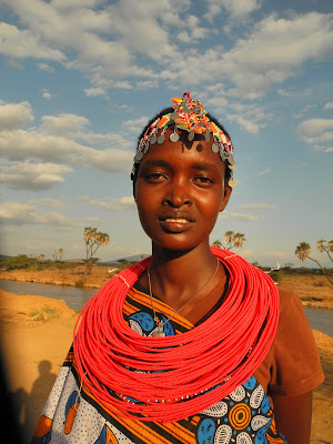
We visited the Samburu people, better to say some ladies of the Samburu tribe who have established a little community by themselves after escaping from their nasty husbands and try to make their living in female community only. It was a nice experience, we did not know that ARTE (yes, the German French TV channel) has been there some time before to make a documentary about them and giving them a sort of star-status, but nevertheless it was unique. After we were shown their homes and daily life, there were very impressed by our own home and we ended up having two Samburu girls chilling in our roof tent. The Samburu are very proud people who do not seem to have great interest of adopting a Western style of living, hopefully this will last for some time longer.
Our goal was to drive further North-West where we wanted to do some camel-trekking in the desert and interact with some tribes but Mohamed, one of the Samburu people we met, along with others told us that we should not attempt this on our own. The tribes up there are fighting in-between each other over the cattle which is driven more and more towards the West because of the drought in the East. So they strongly recommended that we change our route or that we take a soldier with us who speaks the language, so that when and/or if we get stopped by bandits with guns he can do the talking for us... Since we are both chickens and not into gun-situations whatsoever the decision, although a bit disappointing, was easy to take, we change the route and head back to safe grounds.
The safe grounds turned out to be the Lakes Bogoria and Baringo in the Rift Valley. In Lake Bogoria we camped in the wild with eyes staring at us in the dark, animals instead of bandits with guns, we tried to convince ourselves that this was safer... The lake is populated by about 2 million flamingos, extremely few tourists and hot springs and geysers all over the place. Lake Baringo was more of a social experience. We met Attila, a Hungarian born in England raised in Canada living in Austria with whom we spend hours and at least two full days chatting about his millions of experiences around the world in the local “bar” of the village meeting some more of the locals.
We feel that we have seen enough of Kenya and so we plan to head towards Uganda now! We will let you know soon how it is!